
TrueNorth Geospatial is mapping software for backcountry Enthusiasts, Professionals and the outdoor industry
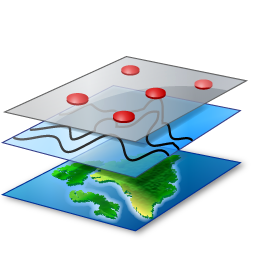
Layers
TrueNorth uses the concept of layers of data similar to a Geographic Information System – in fact, under the surface TrueNorth is a GIS. You can consider a layer like a transparent sheet of mylar you can draw on – except the data on each sheet can come from the local hard drive, from a web-based mapping data set like Google Maps, it can be the track downloaded from a GPS unit, or it can be the live display of position data showing where you are.
You can re-order the layers, mark them up with your own features and annotations, export and import, or just turn off the ones you don;t need to see right now.
Layers give TrueNorth the power to bring in data from different sources and display it in the most appropriate context for your needs.
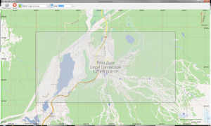
Professional Printed Output
We know that the value of the map is the ability to take it with you, and printed maps are still a large part of this – they can be bigger, lighter, more durable, and most importantly they don’t require batteries.
Don’t worry, we still support digital and mobile devices, but our commitment to flexible, and professional printed maps is one of TrueNorth’s central values. Printing is as simple as selecting a printer, a scale, a paper size and orientation, and then hitting print. And be sure to check out our poster print feature – plotter sized output from consumer grade printers.
Never be lost again!

Extensible Architecture
How’s that for a geeky detail? Bragging about architecture on the front page of a product’s web site? Well we’re not going to apologise, we’re just that proud of TrueNorth’s design.
TrueNorth is designed from the ground up using the principles of inversion of control which gives us incredible power and flexibility on how to configure the product – so much so that the core framework that holds TrueNorth together can be distilled into a single file of code that manages the loading of the various plugins.
We could go on for hours about this but to make it short and sweet read more about our 64 bit architecture, the .NET Framework and the extensibility and we’ll move on to another major feature below.
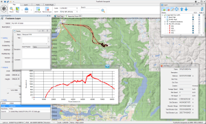
User Interface
One of the things we know about maps is that one is never enough – sometimes you need to look at the same map at more than one scale to get detailed information about an area while maintaining the context of how that piece of geography relates to the rest of the world. Other times you need to look at the same area with data from two different data sets. We decided to support all of this and more.
TrueNorth Standard, Professional and Enterprise editions are designed around a mult-window dockable user interface that lets you open multiple maps or the same map in different windows. Information about the map, layers, and features is also displayed in smaller views, each of which can be dragged to any monitor, and docked (snapped together) with any other window.
TrueNorth Borealis is designed from the ground up to be a lighter, tablet ready version of TrueNorth with specific features for usability on mobile platforms.
TrueNorth is a general purpose mapping tool. Whether you’re an active backcountry adventurer, or you have a job that takes you to remote places, TrueNorth gives you the tools you need to plan, navigate and analyse the terrain.
Download a fully functional demo of TrueNorth, free, for 90 days. Try it, and send us feedback. We’re happy to hear from you.

Standard
 $145
$145
- Multi window UI
- Layers & multiple maps
- Analytical & editing tools
- Online support
Professional
 $400
$400
- Geospatial file formats
- Report quality printing
- Analytical & editing tools
- Professional support
Enterprise
 $1700
$1700
- Database integration
- 3rd party software
- Custom development
- Superior support